


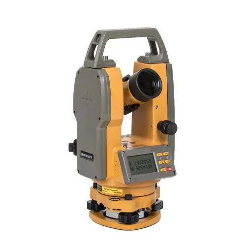
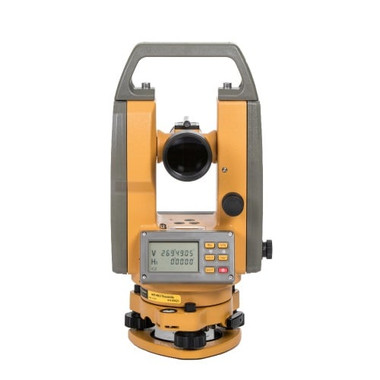
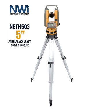
- Northwest Instruments NETH503 5″ Digital Transit-Theodolite
- Hard carrying case
- Rain cover
- Alkaline batteries & battery pack
- Adjusting tools / toolkit
- Silica gel
- User manual
| Northwest Instruments NETH503 5″ Digital Theodolite — Full Specifications | |
| Telescope | |
| Image | Erect |
| Magnification | 30x | Stadia ratio 1:100 |
| Effective Aperture | 45 mm |
| Resolving Power | 4″ |
| Field of View | 1°20′ |
| Minimum Focus | 3 ft |
| Angle Measurement | |
| Measuring Method | Photoelectric Incremental Encoder |
| Minimum Reading | 5″ |
| Detection Method | Horizontal Single, Vertical Single |
| Measuring Unit | 360° |
| Accuracy | 5″ |
| Sensitivity of Vial | |
| Plate Vial | 30′ / 2mm |
| Circular Vial | 8′ / 2mm |
| Optical Plummet | |
| Accuracy | ±2mm |
| Magnification | 3x |
| Field of View | 5° |
| Instrument | |
| Display | Double sided LCD (back-lit) |
| Operating Time | 80 hours (alkaline) | 40 hours (rechargeable) |
| Power | 4 x AA Alkaline or Rechargeable Battery Pack |
| Operating Temperature | −50°F to 120°F |
| Data Output | RS-232C |
| Angle Retention | Power-off angle memory (absolute encoder) |
| Weight | 10 lbs |
Contractors rely on digital theodolites to lay out building foundations, set column lines, and verify structural plumb on walls and towers. Precise angular measurements ensure every element aligns to the design before concrete is poured or steel is erected.
Surveyors use theodolites as their primary instrument for measuring horizontal and vertical angles when establishing property boundaries, control networks, and topographic maps. They form the backbone of every legal land description.
Civil engineers use theodolites to set horizontal curves, super-elevation transitions, and alignment stakes for roads and highways. Bridge projects depend on precise angle measurements to position pier footings and abutments to fractions of a degree.
Underground utility contractors use theodolites to lay out pipe routes, manholes, and sewer inverts with the correct grade and alignment before trenching begins. Accurate measurements prevent costly re-digs when pipes must tie into existing infrastructure at precise invert elevations.
Mine surveyors use theodolites underground and on open-pit benches to control tunnel headings, track blast-hole patterns, and monitor slope movement. Precise traverses tie underground workings to surface control networks for safe passage and accurate ore volume calculations.
Upstream and midstream operators use theodolites to align wellhead equipment, set pipeline right-of-way stakes, and position platform structures. Facility surveyors also monitor structural settlement and equipment alignment at refineries and compressor stations.
Electrical and telecom crews use theodolites to set transmission tower centers, sight utility pole lines, and check conductor sag across long spans. Precise readings keep high-voltage infrastructure aligned and within required right-of-way corridors.
Military engineers use theodolites to establish artillery firing positions, orient weapon systems, and create accurate topographic surveys in field conditions. They are also used for azimuth transfer when setting up communications arrays and radar installations.
Forestry professionals use theodolites to measure tree heights, set boundary lines for timber tracts, and lay out logging roads through difficult terrain. Accurate vertical angle readings allow crews to calculate standing timber volumes without felling a single tree.
Archaeologists use theodolites to create precise site grids, record the exact position of artifacts and features, and document excavation profiles in three dimensions. This accuracy preserves spatial context critical for interpreting stratigraphy and publishing reproducible site maps.
Agricultural engineers use theodolites to design drainage channels, land-leveling projects, and irrigation system layouts across large fields. Setting precise grades ensures water flows correctly to crops and prevents pooling or erosion that reduces yield and damages soil structure.
Municipal surveyors and planners use theodolites to establish control monuments, verify cadastral boundaries, and collect angular data that feeds into GIS databases. Accurate base measurements ensure zoning, infrastructure, and development records remain legally defensible over time.

- ✓ 5″ Digital Theodolite
- ✓ Hard carrying case
- ✓ Alkaline batteries & rain cover
- ✕ Tripod not included
- ✓ 5″ Digital Theodolite
- ✓ Hard carrying case
- ✓ Alkaline batteries & rain cover
- ✓ SitePro ALQR20 HD Tripod


