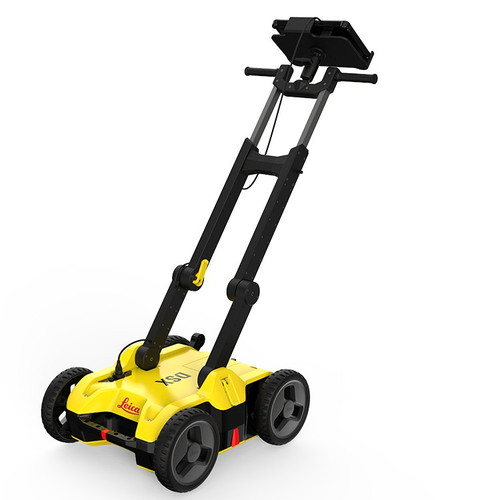


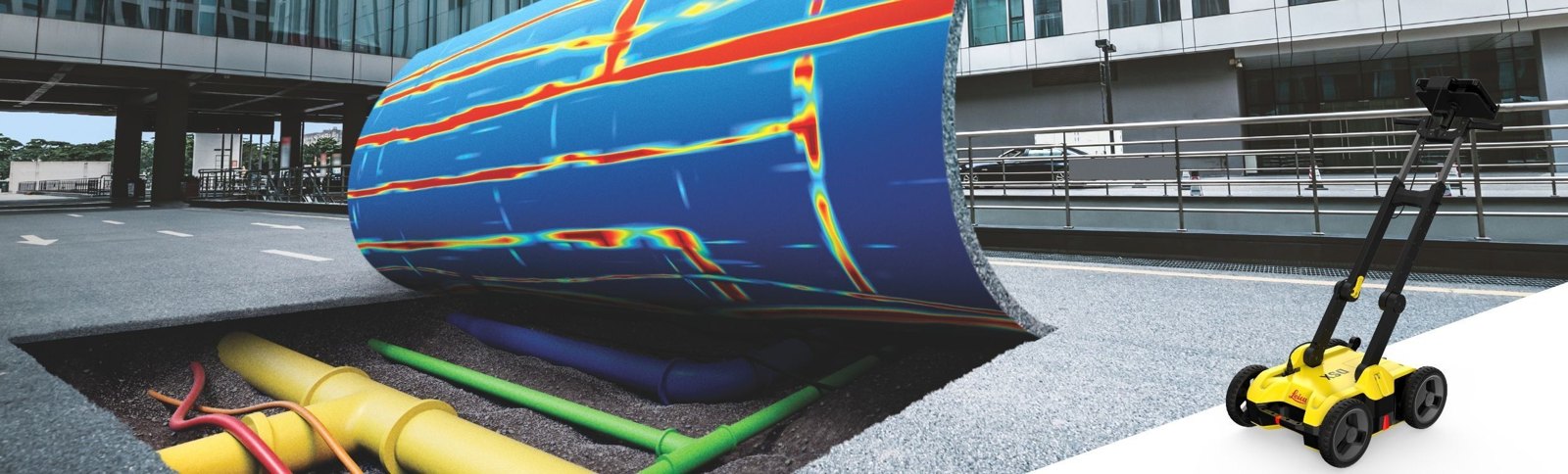
Utility radar anyone on your crew can run
The DXplore software reads the radar for you and builds a 3D utility map on the tablet in minutes, on site. No hyperbolas to interpret, no waiting days for office processing.
- Finds metallic and non-metallic utilities, including plastic pipe
- Automatic 2D / 3D utility map on site
- Export DXF, DWG, SHP and a PDF report; send to Leica MC1 machine control
- Up to 8 hours per battery, IP65
How it works: we help you choose and order, then Leica Geosystems ships the DSX to you and supports it directly.
Compare DSX packages
Every kit has the same DSX radar. Starter kits map utilities; Surveyor kits add GNSS / total station georeferencing and MC1 machine control export. Choose perpetual to own the DXplore licence, or subscription to start for less.
| DSX SystemLeica part 880935 | Starter Kit, PerpetualLeica part 6015139 | Starter Kit, SubscriptionLeica part 6015140 | Surveyor Kit, PerpetualLeica part 6015141 | Surveyor Kit, SubscriptionLeica part 6015142 | |
|---|---|---|---|---|---|
| Leica list price | $13,915.00 | $21,170.00 | $18,445.00 | $25,920.00 | $21,155.00 |
| DSX utility detection radar | ✓ | ✓ | ✓ | ✓ | ✓ |
| CT1000 rugged tablet controller | — | ✓ | ✓ | ✓ | ✓ |
| DXplore Build licence (3D utility map) | — | Perpetual | 1-year subscription | Perpetual | 1-year subscription |
| DXplore Survey licence (GNSS, total station, MC1 export) | — | — | — | Perpetual | 1-year subscription |
| PS1000 pole support | — | — | — | ✓ | ✓ |
| 2-year DSX Basic CCP | — | ✓ | ✓ | ✓ | ✓ |
| 2-year DXplore CCP | — | ✓ | — | Build + Survey | — |
| Best for | Adding a radar to a tablet and licence you already have | Own the software outright | Lowest cost to start mapping | Own it all: georeferenced maps and MC1 export | Georeferenced maps on a subscription |
| What’s in the box (Leica’s wording) |
|
|
|
|
|
Swipe the chart sideways to see all five packages.
Contents are Leica’s wording from the Leica price list. CCP = Leica Customer Care Package (support plan). Prices are Leica list and may change; call to confirm current pricing and the full box contents. A GNSS antenna is not included in any kit; Leica offers GNSS and FLX100 packages for the Surveyor kits.
Tell us whether you mark out or deliver georeferenced maps. We place the order with Leica, and Leica ships and supports your DSX directly.
How ordering works
Reliable utility detection for everyone
A simple detection workflow and results anyone can understand. The DSX cart scans the ground; DXplore on the tablet does the analysis and gives you a 3D map of what is down there before the bucket goes in.
No GPR experience needed
The software does the interpretation. You do not read raw radar data or hyperbolas.
3D utility map in minutes
DXplore builds a 2D / 3D map on site. No waiting days for office post-processing.
Finds plastic, not just metal
Detects both metallic and non-metallic underground utilities.
Send it to the excavator
Export the map to Leica MC1 machine control so the operator sees the utilities in the cab.
CAD-ready deliverables
Export utilities to DXF, DWG and SHP, plus a configurable PDF report before you leave site.
A full shift on one battery
Up to 8 hours of operating time on the 14.8 V Li-ion battery.
Built for the jobsite
IP65 cart on solid rubber tyres, no flats to fix; IP65 / MIL-STD-810G tablet.
Scan at walking pace
Collects data at up to 7 km/h (4.3 mph), normal walking speed.
Survey-grade maps
Add Leica GNSS or a total station with DXplore Survey for georeferenced utility maps.
Check against the plan
Load the utility records you have (DXF, DWG, ESRI shape) and POIs like manholes and hydrants.
Walks you back to the line
“Back to utility” and “lead to utility” guide you to each line for marking out.
Pay your way
DXplore comes as a perpetual licence, a 1-year subscription or a rental.
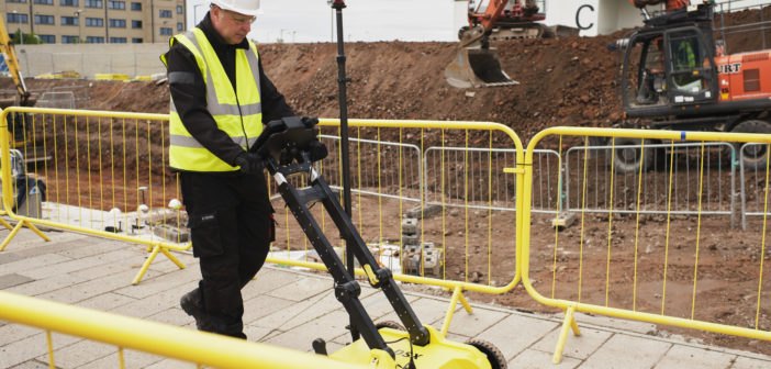
Scan anywhere, at any time
Leica built the DSX to work even in narrow areas and under severe conditions. The handle adjusts in height and angle and folds for transport.
Why it pays: Leica cites industry figures that a project shut down by a utility strike can easily cost $2,000 or more per hour, and a Purdue University study that companies save $4.62 for every dollar spent on utility detection.
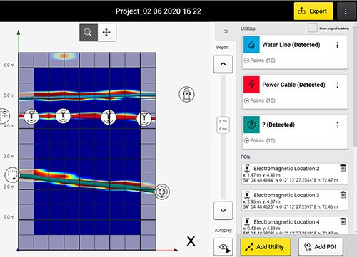
Results you can read
- Slice through the 3D image by depth and animate through the slices
- A smart algorithm helps verify each detected utility
- B-scan view to check ground conditions and mark anomalies
- Quick Scan mode for a fast check before a full grid
See the DSX at work
Introducing the Leica DSX Utility Solution (1:45), from Leica Geosystems.
More DSX videos: walkthrough, how-tos and a customer story (8)
Ground Penetrating Radar, A Step-By-Step Walkthrough Of The Leica DSX Detecting Utilities
How to Video: Leica DSX - Initial Set Up
How to Video: Leica DSX - Setting Up a Grid Using EML and Collecting Data
How to Video: Leica DSX - Using DXplore with a GNSS Antenna
How to Video: Leica DSX - Accessing and Picking from a Previous Project
Leica DSX Utility Detection Solution
Waskita project - An easy-to-use solution to prevent utility accidents with Leica DSX
On Demand - Leica DSX Ground Penetrating Radar
Collect, map, excavate: Leica’s 3-step workflow
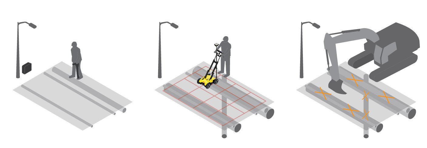
1. Collect information
Call 811 and get the utility records, then load them into DXplore. Sweep with a cable locator for power and conductive lines and mark them on the ground.
2. Map utilities
Lay out a grid (4 x 4 m to 11 x 11 m, lines every 0.5 m / 18 inch) with the GAS1000 grid square, scan both directions, and DXplore builds the 3D utility map on site. Add Leica GNSS for a georeferenced map.
3. Excavate safely
Mark out the utilities on the ground, or send the map straight to the excavator with Leica MC1 machine control.
DXplore Build vs DXplore Survey
Starter kits come with Build. Surveyor kits add Survey for positioning and machine control.
| Feature | Build (Starter) | Build + Survey (Surveyor) |
|---|---|---|
| Grid Scan and Quick Scan | ✓ | ✓ |
| On-site radar tomography, 2D / 3D view, depth slices | ✓ | ✓ |
| B-scan review and marking | ✓ | ✓ |
| Utility marking, semi-automatic verification, “back to utility” | ✓ | ✓ |
| Google Maps background and current location | ✓ | ✓ |
| Configurable PDF report | ✓ | ✓ |
| Export detected utilities in DXF, 3D DXF / DWG; images in PNG, JPG, TIFF, BMP, GIF | ✓ | ✓ |
| GNSS and total station connection wizard, georeferencing | — | ✓ |
| Local coordinate systems, geoid corrections | — | ✓ |
| Import utility records in DXF, DWG and ESRI shape file | — | ✓ |
| “Lead to utility” viewer | — | ✓ |
| Leica MC1 machine control export (.lok) | — | ✓ |
Complete the locate
Leica DSX specifications
| Radar | |
|---|---|
| Antenna | Single frequency, 600 MHz central frequency, 1 channel |
| Antenna footprint | 40 cm x 50 cm |
| Detection depth | Up to 2 m (6.56 ft), depending on soil conditions |
| Acquisition speed | Up to 7 km/h (4.3 mph) |
| Scan rate | 381 scans/s per channel; 42 scans per metre |
| Grid scan interval | 0.50 m (18 inch) |
| Grid size | 4 x 4 m (12 x 12 ft) to 11 x 11 m (33 x 33 ft) |
| Positioning | 2 encoders in the rear wheels; GNSS antenna or total station with DXplore Survey |
| Cart | |
| Weight | 23 kg without battery and tablet |
| Wheels | Solid rubber tyres, no pumping |
| Handle | Adjusts in height and angle, folds for transport |
| Protection | IP65 (IEC 60529) |
| Humidity | Max 95%, non-condensing |
| Operating temperature | -10 to +40 °C (14 to 104 °F) |
| Storage temperature | -40 to +70 °C |
| Battery | |
| Type | GEB242 Li-ion, 14.8 V / 5800 mAh |
| Operating time | Up to 8 hours |
| Charger | GKL312 with GEV192-9 AC/DC adaptor |
| CT1000 tablet (in Starter and Surveyor kits) | |
| Display | 11.6 inch sunlight-readable touchscreen with hard-tip stylus |
| Computer | Intel Core i3-7100U, 4 GB RAM, 128 GB SSD, Windows 10 Professional |
| Connectivity | GPS, WiFi, Bluetooth v4.2, 4G LTE; RJ45 to the DSX |
| Rugged rating | IP65 / MIL-STD-810G |
| Weight | 1.39 kg |
| Battery | Li-ion 11.4 V / 2160 mAh |
| Software and warranty | |
| Software | DXplore Build; DXplore Survey on Surveyor kits; perpetual, subscription or rental |
| Exports | DXF, 3D DXF / DWG, SHP; PNG, JPG, TIFF, BMP, GIF; PDF report; MC1 (.lok) |
| Warranty | DSX 2 years; CT1000 2 years global (battery 1 year) |
| Radio | FCC ID RFD-CTDSX |
Sources: Leica DSX data sheet 896479 (2021), Leica DSX brochure (01/2024), Leica DSX user manual v1.2, Leica US shop, Leica price list. Depth uses the conservative 2 m figure from the user manual and Leica shop.
Leica DSX vs Leica DS4000: which radar?
Both are Leica utility detection radars that Contractors-Tools.com can help you order. Here is how they compare, from Leica’s own documents.
| Leica DS4000 | Leica DSX (this page) | |
|---|---|---|
| Made for | Crews who want dual-frequency radar, real-time tomography in uMap and 3D processing in IQMaps | Crews new to GPR: DXplore reads the radar and builds the 3D utility map on site |
| Antenna | Dual 200 MHz and 900 MHz, 2 channels, HH / VV polarization | Single 600 MHz, 1 channel |
| Depth | Up to 60% deeper than traditional systems (Leica gives no absolute depth) | Up to 2 m (6.56 ft), depending on soil |
| Weight | 20 kg (44 lb) | 23 kg without battery and tablet |
| Battery | 4 hours per battery, 8 hours with two, hot swap | Up to 8 hours per battery |
| Operating temperature | -20 to +50 °C (-4 to +122 °F) | -10 to +40 °C (14 to 104 °F) |
| Protection | IP65 | IP65 |
| Tablet in the kits | No: Leica recommends the CT1500, sold separately | Yes: CT1000 in every Starter and Surveyor kit |
| Office software | IQMaps (sold separately) with direct AutoCAD export | DXplore licence in every kit; DXF, DWG, SHP and PDF export |
| Leica list price | System $16,900; kits from $21,265 | System $13,915; kits from $18,445 |
Tell us who will run it and what you need to hand the client. We will point you to the right radar and package.
DSX documents
More Leica at Contractors-Tools.com: Leica Geosystems at Contractors-Tools.com • Locators and underground detection.
Leica DSX questions, answered
Do I need GPR experience to use the Leica DSX?
No. Leica built the DSX for first-time GPR users. DXplore does the data processing, so you do not have to read raw radar data or interpret hyperbolas, and Leica says even a user with no previous GPR experience can detect utilities on site. Built-in animated tutorials walk you through setup.
How deep does the DSX see?
Up to 2 m (6.56 ft), depending on soil conditions.
Will the DSX find plastic pipe?
Yes. The DSX is designed to detect and locate both metallic and non-metallic underground utilities.
How long does a battery last?
Up to 8 hours of operating time on the 14.8 V / 5800 mAh Li-ion battery. Leica recommends carrying a second charged battery.
What is the difference between the Starter and Surveyor kits?
Both include the DSX radar, the CT1000 tablet and DXplore Build. The Surveyor kit adds the PS1000 pole support and the DXplore Survey licence. Survey adds GNSS and total station connection, georeferencing, local coordinate systems, import of DXF, DWG and SHP utility records, and MC1 machine control export.
Perpetual or subscription: which should I buy?
Perpetual kits include a DXplore licence you own plus a 2-year DXplore CCP. Subscription kits include a 1-year DXplore subscription and cost less up front. Both include the CT1000 tablet and a 2-year DSX Basic CCP.
Can I tie the utility map to GPS coordinates?
Yes, with DXplore Survey and a supported antenna: Leica GS14, GS16, GS18 T, iCON gps 70 / 70 T, GG03, GG04 or GG04 plus, or the FLX100 handheld package for DSX. The antenna must be multi-frequency (L1 + L2 + L5), update faster than 5 Hz, and be Bluetooth and RTK capable. Leica recommends the GS18 T.
What file formats can I export?
Detected utilities in DXF, plus 3D DXF / DWG; the brochure also lists SHP. Tomography images in PNG, JPG, TIFF, BMP and GIF. A configurable PDF report made on site. MC1 machine control export with the Survey licence.
Can it send the utility map to my excavator?
Yes. You can send the map straight to an excavator running Leica MC1 machine control, or to DX Manager Mapping, Infinity or Captivate.
How big an area can I scan at once?
A grid from 4 x 4 m (12 x 12 ft) up to 11 x 11 m (33 x 33 ft), square or rectangular, scanned in lines every 0.5 m (18 inch) in both directions. For a fast first look, use Quick Scan mode.
Is the DSX weatherproof?
The DSX is rated IP65 and works from -10 to +40 °C (14 to 104 °F). The CT1000 tablet is IP65 / MIL-STD-810G with a sunlight-readable screen.
How heavy is it?
The DSX weighs 23 kg without battery and tablet. The handle folds for transport, and the solid rubber tyres never need pumping.
What does the DSX System (880935) need to run?
The System is the radar cart with its mount, battery, charger and cables. DXplore will not run without a valid licence, so you also need a tablet and a DXplore licence. The Starter and Surveyor kits include both.
What warranty comes with it?
Leica gives the DSX a 2-year warranty, with extension CCPs available. The CT1000 tablet has a 2-year global warranty (battery 1 year). Every kit includes a 2-year DSX Basic CCP.
How do I order the DSX?
Call Contractors-Tools.com at 1-877-866-5721. We help you choose the right package and place the order with Leica Geosystems, which ships the DSX to you and supports it directly. That is why there is no Add to Cart button on this page.